
How many customers are within x miles of me? This is a simple question that so many organizations struggle to answer. One version of the truth becomes difficult with proximity based analysis if your methods are inconsistent.
For example, driving miles are different from radius (“as a crow flies”), which may result in different data depending on your road network data and algorithms used to calculate drive distance. There are many different ways to approximate distance and time, and CMaps Analytics covers them all starting with basic radius based analysis, to complex drive time based polygons, powered by geospatial services.
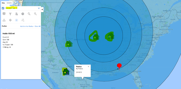
Basic distance based analysis is 1 click away with our new radius analyzer in the latest release of CMaps Analytics JS API.
Now, you can ask more sophisticated questions like:
“How many customers are within 20 miles and what is their total value?”
In addition to showing 1 or multiple bands from any location, CMaps Analytics will calculate metrics on the fly using your data.


Want to do more sophisticated comparative analysis in multiple regions or inject drive time polygons with traffic congestion data? Contact us for more details to extend our radius analyzer for a deeper level of Location Intelligence.
]]>