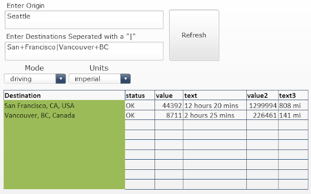
GMaps Plugin and GMaps Mobile with more robust location analytics, we wanted to share an interesting, upcoming feature where you can take utilize drive distance and times between points of interest. Unless your organization has helicopters or time travel machines for routing assets and employees, driving distance and time could improve your accuracy for business scenarios that rely on routing people and assets. For example, a heavy machinery equipment company that needs to route assets probably needs the shortest drive distance to make good decisions in addition to a basic linear distance.
HOW WOULD YOU USE DISTANCE MATRIX DATA IN YOUR DASHBOARDS?
As we incorporate these exciting new features into our GMaps Suite, we want to hear how you would want to incorporate analytics based on driving distance into your dashboards and Business Intelligence Apps. You can look forward to these kinds of services to be thoughtfully integrated into our solutions to fit your business intelligence needs. Here is a very simple template that we created for you to test this concept and see how it can help your dashboard implementation. The community would love to hear about your business cases.